Description
Sub Bottom Profilers are one of the most effective tools used to identify and characterize layers of sediment or rock under the seafloor. The sub bottom profiler is similar to that of a simple echo sounder. A transducer releases a sound pulse vertically downwards towards the seafloor, and a receiver records the return of the pulse once it has been reflected off the seafloor. Unlike a simple echo sounder, parts of the sound pulse will penetrate the seafloor and be reflected off of the different sub-bottom layers or strata layers. This will show any sort of density disturbance which will indicate to the user that there is something foreign beneath the surface.
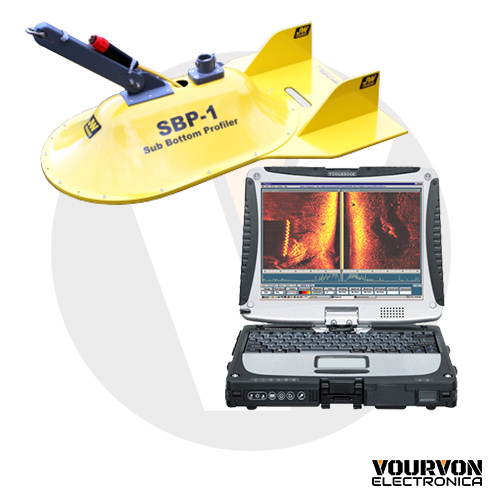
Fishers’ SBP-1 has an advantage over most other competition as this unit is either pole mountable for shallow water searches or boat tow-able for search in deeper areas allowing superior versatility for the end user. The SBP-1 system includes the sonar towfish constructed of corrosion proof, high impact PVC, 150’ of cable (additional lengths are available up to 1,000 feet), the topside sonar processor box and laptop computer pre-loaded with the JW Fishers SONAR VIEW for Sub Bottom Profiler software. The 36-inch-long by 24-inch-wide towfish provides a very stable platform for the sonar transducer allowing the best possible images to be obtained. The SBP-1 is capable of penetrating up to 130 feet into the seabed. The sonar beam reflects off any solid objects below the seafloor and is sent topside for display and storage on the computer. An image is produced of any target of different density than the surrounding substrate.
The provided laptop computer is fully equipped with Fishers’ SONAR VIEW for Sub Bottom Profiler software. The SONAR VIEW software gives the sub bottom operator complete control of all system functions with easy to use pull-down menus and icons on the screen. Size measurement tool annotation and auto bottom tracking all standard. The operator can change colors, ranges, amplifier gain, and other controls with a click of the mouse. With the computer, sub bottom images can be stored in memory for playback and post processing at any time in the future. Small file sections including screen shots can be copied for emailing. With the GPS connected to the computer the position coordinates are captured with the data. When a GPS is connected, the mouse cursor can be placed on any object on the screen and its position coordinates will be displayed. Sonar files can be stored on the computer’s hard drive.
An optional Panasonic Toughbook® is available for small, open boat operations (see image on side). The 10.1″ XGA sunlight-viewable LED 1024 x 768 resistive touchscreen computer can be ordered as an option for the Side Scan system instead of the standard laptop. This computer is MIL-STD-810G certified (6′ drop, shock, vibration, rain, dust, sand, altitude, freeze/thaw, high/low temperature, temperature shock, humidity, explosive atmosphere).
The optional Sonar Coverage Mapping software (boat tracking software) shows the boat’s path as it travels over the search area. It’s all displayed on a grid with latitude and longitude as the X and Y axis. This option makes it easy to search even large areas and ensures no part of the area is missed. The map can be shown in a separate window on the same screen as the sub bottom image, or the map can be displayed on a separate monitor. The user can also control the size of the map. The map can be exported as an image with a KML file to allow it to be easily overlaid on other mapping programs (as shown at the right). All data can be stored on the PC hard-drive or disk.
An optional Panasonic Toughbook® is available for small, open boat operations (see image on side). The 10.1″ XGA sunlight-viewable LED 1024 x 768 resistive touchscreen computer can be ordered as an option for the Side Scan system instead of the standard laptop. This computer is MIL-STD-810G certified (6′ drop, shock, vibration, rain, dust, sand, altitude, freeze/thaw, high/low temperature, temperature shock, humidity, explosive atmosphere).
The Cable management systems are cable reels with slip rings which allow complete operation of the system while deploying or retrieving cable. CMS-1 cable reel holds 500 feet of Sub Bottom cable and is housed in a Pelican 1620 case. The CMS-2 cable reel holds 1,000 feet of Sub Bottom cable and is housed in a Pelican 1660 case. Both cases come with wheels and a retractable handle for ease of transportation and storage.
Ideal for cable and route surveys, dredge and hazard surveys, sediment classification, and detection of buried objects including pipes and cables.
Fishers Sub Bottom Profiler receiver is ruggedly built for commercial operations and is covered by a full TWO YEAR WARRANTY.


